WE HELP YOU SEE
THE HARD TO REACH PLACES
Drone FAçade Surveys
for Structural AssessmentS
SkyData UAV supplements milestone inspections of high-rise condominiums with precision and high-quality drone imaging services. Structural engineering firms rely on SkyData UAV’s proven processes and FAA-licensed pilots to meet State of Florida inspection requirements for high-rise condominiums. With a portfolio of more than 90 high-rise drone surveys, SkyData UAV has become the trusted source for structural engineering and construction firms, as well as condominium associations across Miami-Dade, Broward, and Palm Beach counties.
From roofs and balconies to window frames and façades, and the confined spaces beneath and inside, we collect high-resolution photographs and 4K video, as well as produce 3D models that provide the details you need to assess building envelope conditions.
On construction job sites, our UAV mapping accurately captures high-resolution and precisely located images by using real-time kinematic positioning (RTK) to produce maps and volumetrics with the most advanced data processing software. Our results are detailed, accurate and organized, and can be easily incorporated into your reports.
Drone Surveys of Condominium Façades in South Florida
In South Florida, high-rise façades are constantly exposed to salt air, intense sun, and hurricane-force winds. With Florida’s milestone inspection requirements for aging condominium buildings, documenting exterior conditions is not optional — it’s mandatory. SkyData UAV helps structural engineers meet these requirements efficiently and safely.
Safer, Faster Building Envelope Surveys
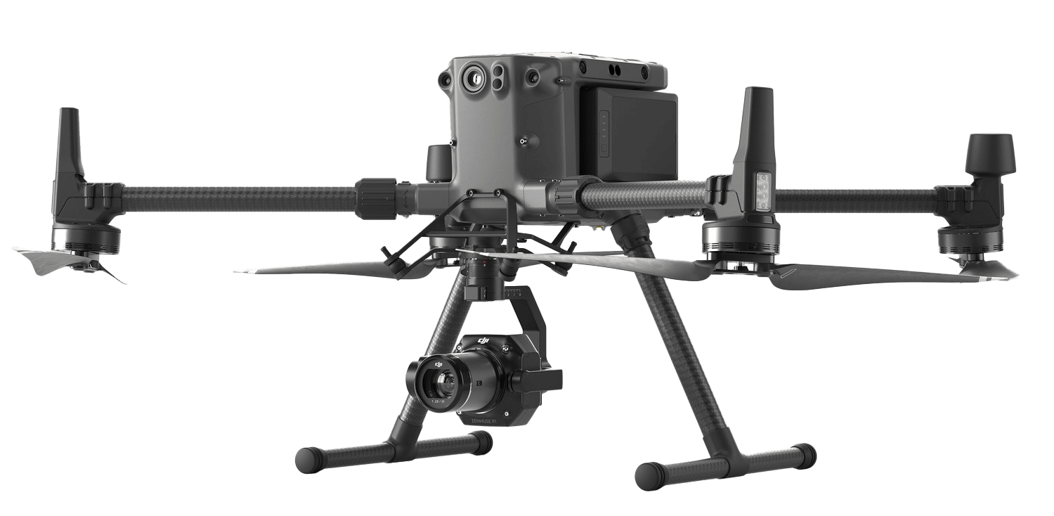
SkyData UAV provides a safer, quicker alternative to swing stages and rope access. Our FAA Part 107–licensed pilots perform precise vertical drone surveys that capture high-resolution stills, 4K video, and 3D data of the entire building envelope — including façades, roofs, balconies, window systems, and hard-to-reach areas.
Actionable Visual Data for Engineers
Our service reveals hidden problems and pinpoints their exact locations on the structure — from spalling concrete and rusting rebar to cracked balconies and failing sealants. We provide organized image sets, elevation overlays, and condition logs, enabling engineering teams to analyze data more efficiently, complete milestone reports, and design repairs with greater confidence and reduced field time.
FAA Part 107–licensed pilots conduct precise vertical drone surveys that capture high-resolution photographs, 4K video, and other data across the entire building envelope — including façades, roofs, balconies, window systems, and difficult-to-access areas.
Proven Partner for Milestone Inspections
With a portfolio of more than 90 high-rise drone surveys, SkyData UAV is a trusted partner to structural engineering firms and condominium associations across Miami-Dade, Broward, and Palm Beach counties. Our proven processes and FAA-licensed pilots enable firms to help meet the State of Florida’s inspection requirements for high-rise condominiums with precision and consistency.
UAV Services
Drone Façade Surveys for Engineers
Detailed vertical surveys of high-rise buildings deliver images and video to locate otherwise hard-to-see spalling, rust, exposed rebar, broken concrete and other deficiencies
Construction Progress Photos and Video
Drone photographs are used to make maps and models that enable you to compare and contrast between the designed and final specifications of a construction project.
Drone Infrared Roof Inspections
Our Level-1 certified thermographer captures images of flat and sloped asphalt roofs to help identify water intrusion.
Confined Space Inspections
We use advanced drone technology to safely collect high-resolution images and video of confined spaces in buildings, storage facilities and power plants.
UAV Mapping and Stockpile Volumes
Using RTK drones and RTK base stations, our pilots collect detailed photographs to map construction sites that have stockpiles. We process the data with proven software to produce stockpile volume reports.
Drone Roof Inspections for Commercial and Residential Buildings
SkyData UAV provides detailed photographs and maps of sloped and flat roofs on warehouses, apartment buildings, retail centers, condominiums, and office and educational campuses, saving time for engineers and insurance adjusters to inspect for damage.
3D Drone Surveys for Modeling Buildings
The next generation of image capture converts drone photographs into 3D building models, enabling structural engineers to identify and quantify defects, track trends in areas of a building, and measure changes over time.
Pre-hurricane Condo and Commercial BUILDING Surveys
Prior to hurricane season, we provide condominium associations and building owners with photographic documentation of their buildings’ existing façade and roof conditions. Images, video and data are stored remotely for two years.
Certified Small Business
SkyData UV has passed the rigorous standards of small business certification.
We are registered with Broward County, Broward County Public Schools
Palm Beach County Schools and the South Florida Water Management District
THE BIRD’S EYE VIEW
Drone service for high-rise building roofing and façades.
4K VIDEO
4K is ultimate high definition allowing for more granular details.
customization
We pride ourselves on our ability to meet your unique needs.
AERIAL PHOTOS
From confined internal spaces to high-rise exteriors, we cover all the angles you want.
Why Choose SkyData UAV for Your UAV Building Survey?
Experienced Drone Service Company
- More than 90 high-rise buildings surveyed
- Extensive experience safely flying over and mapping construction job sites, collecting images for drone roof inspections, and imaging inside confined spaces.
- Part 107 licensed pilots with specialized expertise and equipment.
Quality and User-Friendly Reports
- High-resolution images allow you to see the slightest imperfections
- Advanced 3D modeling enables you to pinpoint deficiencies and produce organized and timely reports for your clients.
Compliance and Safety
- We obtain Federal Aviation Administration approvals when flying near airports to guarantee safe and legal drone surveys.
- Adhere to FAA drone safety and OSHA job site safety requirements.
Insurance and customization
- $5 million liability insurance policy
Our Process
Initial Consultation
Ensure that we understand your needs and objectives for the UAV survey project.
Scope of Work
You receive a detailed scope of work to ensure everything is understood clearly
Pre-Flight PLanning
We define the survey area, determine the flight path, assess potential risks and ensure regulatory compliance.
Survey and Inspection
The FAA-certified pilot flies the drone according to the prescribed flight path and captures high-resolution imaging and data.
Data Processing and Quality Control
We process the data to generate a report that specifies flight paths and notes problem areas. We perform quality assurance to make sure it meets your needs.
Report Delivery
We provide you with the final report that may highlight findings.
WE'RE ABOUT QUALITY
AND TRUST.
Buildings Surveyed
Served
Completed
Height Surveyed
Case Studies
Monthly Water & Sewer Construction Progress Photography
Ric-Man International of Pompano Beach, FL, hired SkyData UAV to capture pre-construction video of 23.4 miles of roads, sidewalks, and driveways in Lauderdale Lakes, FL. SkyData also delivered maps covering 294 acres, documenting construction progress every month for Broward County.
Condominium Drone Roof Inspection and Vertical Survey
Port Everglades Parking Garage Construction Progress Photography
SkyData UAV documented the construction progress of a six-story parking garage at Port Everglades. Using StructionSite, SkyData integrated geo-referenced coordinates and photographs into the construction management software.
Construction Progress Photography: Hialeah Charter School
OUR Clients


OUR TEAM

David Oakes
President / Pilot
- Remote Pilot in Command since 2016
- 350+ hours of drone flight time
- Former journalist and marketing manager

Anand Maharaj
Chief Pilot
- Licensed FAA / TC- ATPL – 40 years / 20,000 hours flying multiple types of passenger and freight aircraft
- Remote Pilot in Command since 2018
- AUVSI Top Level 1
Case Studies
- Monthly Water & Sewer Construction Progress Photography
Ric-Man International of Pompano Beach, FL, hired SkyData UAV to capture pre-construction video of 23.4 miles of roads, sidewalks, and driveways in Lauderdale Lakes, FL. SkyData also delivered mosaic images covering 294 acres, documenting construction progress monthly for Broward County.
- Condominium Drone Roof Inspection and Vertical Survey
SkyData UAV provided drone services to capture vertical and roof photographs of a 24-story condominium in Miami for Donan Engineering and a public insurance adjuster, delivering detailed mosaic images and close-up photographs of damaged areas.
- Port Everglades Parking Garage Construction Progress Photography
SkyData UAV documented the construction progress of a six-story parking garage at Port Everglades from March 2019 to completion. Using StructionSite, SkyData integrated geo-referenced coordinates and photographs into the construction management software.
- Construction Progress Photography: Hialeah Charter School
SkyData UAV conducted bi-weekly drone flights for 18 months for Sol-Arch, a Miami design/build firm, capturing high-resolution images and data for importing into AutoCAD to measure as-planned versus as-built.